Prelude:
We could hardly wait to get to Waterton-Glacier International Park when we arrived at Kalispell, Montana. We had seen pictures friends had taken and heard their descriptions of the park's beauty. But, since we arrived late in the afternoon at Kalispell, we stopped at the first camp ground we came to. (See Leonard's Campground Review - Part 4)
Spruce Park On The River campground is located on the very south end of Kalispell and is an excellent campground for motorcyclists. The grounds are level and the roads are hard packed gravel. The showers were clean. The owners went out of their way to help us and even allowed us to fish a little from their river bank. The town of Kalispell has everything you would want. Good grocery stores, several restaurants and fast food places and many gas stations.
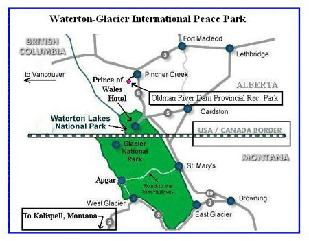 We did a little reading about the park and learned this: Waterton-Glacier International Peace Park stretches for 75 miles from northwestern Montana to Alberta, Canada. In 1932, the adjoining Glacier National Park (Montana, U.S.A.) and Waterton Lakes National Park (Alberta, Canada) were combined to form the first International Peace Park, celebrating the peace and friendship between these two countries. And in 1985, the Going-to-the-Sun Road was dedicated a National Historic Civil Engineering Landmark. In 1995, the Peace Park was recognized as a World Heritage Site.
(I will explain how to get into Waterton-Glacier park from Canada, as we read about that portion of this trip or you can go to the bottom of Day 2 where it is discussed.)
Day 1.
This day our route had us going through the park on the famous “Going To The Sun Highway.” Then at the town of St. Mary we turn South, with a loop back west, which eventually returns north to Kalispell.
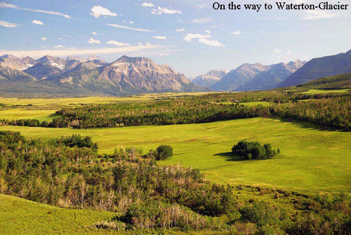 We left the, tow behind the bike, trailer at Spruce Park and headed North West, on U.S. Highway # 2. This would take us to the town of Hungry Horse. The scenery is beautiful right from the start. Traffic seemed a little busy, but everybody was driving decent.
Hungry Horse was a nice small town with everything you would want. Lots of quaint shops. One could spend a good part of the day, just browsing the shops. We made an inquiry at the gorgeous Mt. Meadows campground. But, not only did we find the owners to be very rude, they absolutely do not allow motorcycles or tent campers. Their loss eh? We spotted a road side stand advertising Huckleberry milk shakes, so we had to stop and try one. They were surprisingly good. I suggest you stop and buy one.
|
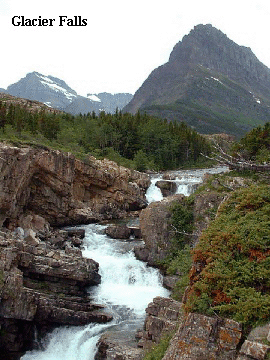
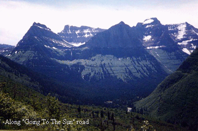
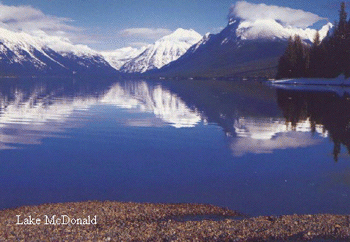 The park road was excellent, with lots of curves and a steady upward climb. But, the road can also be treacherous, so look at the scenery with a little caution. We passed the beautiful Lake McDonald and the water falls spilling onto the edge of the road. Since it was already getting hot, the spray from the falls felt good. Judge the traffic so you can stop for an instant and take a picture of the falls. We rode through Logan's Pass at 6,600 ft. There are wonderful rock formations and color, both before and after the pass. The rocks, trees and streams all make for pretty pictures. In all of our travels, this park seemed to offer more beauty then others we have visited. And the wild life seems to abound. We saw both deer, elk and mountain goats. The park also has coyote, marmot, moose, bighorn ram, coyote, and mountain lion. We saw a couple of the cute marmots, but none of the remaining animals. All total we were told, that there are 260 wildlife species. We learned later that this park has a very high concentration of Grizzly bears. Perhaps not seeing them was a good thing.
 In addition to the animals we learned more than 650 lakes cover deep canyons and forested valleys. Sub-alpine fir, spruce, and pine characterize the eastern portion of the park, while hemlock, red cedar, and lodge pole pine cover the park's western lands.
This is a haven for over 1,000 varieties of plants. Remember, take pictures and leave foot prints. Nothing else. This truly is a hikers paradise.
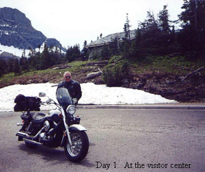
We continued our climb through the spectacular scenery, catching glimpses and a few full views of the numerous glaciers in the park. They were majestic and the glaciers were so white. None are real close to the main road though, but well within picture taking distance. After about 5 hours of riding and stopping we reached the 2/3 mark of the ride. This was the visitor center. And were we glad to get there. It sits at about 9,000 ft and has a very large parking lot. We had no trouble finding a place to park. But, we did learn that during the middle portion of the day, the rangers sometimes turn cars away, because the parking lot does fill up. I think we arrived around 3:00 PM.
 We scurried in to use the personal facilities (wash rooms) and then looked for the snack bar, café or even vending machines. But, none were to be found. And we were starving. So, for lunch all we had was some water and a cheese snack pack we brought along in the saddle bags. No matter what direction you travel on The Going To The Sun Highway, I suggest taking some food and beverages along. Unless you are into wild berries, stream water and road kill.
Shortly after leaving the visitors center, the beautiful Going To The Sun Mountain came into view. After that we were riding along the beautiful shores of Lake St. Mary. Another one of those, “I wish I could live here,” places. About midway down the length of the lake we came across a camp ground called Rising Sun. We stopped to make inquiries, but there was a “be back in 15 minutes” sign on the door. So we walked around and saw that this campground has sided cabins, not log cabins. But they were clean and appeared to be well kept. And the shower building seemed large. However we could not gain access to the inside. There seemed to be a lot of campsites, with a few offering beautiful views. After waiting a half hour for someone to return to the campground office, we departed, never being able to talk to anybody. This campground is only about 6 miles from St. Mary and would be a good site to stay at.
 We arrived at St. Mary and saw it was like most of the mountain towns, in that it is small, but has everything you would want. It seems the town's income balances on the tourist's dollar. Things were a little expensive compared to the lower cities prices. We were still starving, so ate at a café on the west side of the towns main street. We ate in the outside court yard, so we could watch the people. I don't remember the name of the café or what we ate, but I am sure it was good.
After eating, we turned south on Federal highway # 89, 15 miles down to the small town of Kiowa. (When you leave St. Mary, you are leaving the park.) Not much going on at Kiowa, so we breezed on to State highway # 49 which took us west a mile or so before turning south. As we rode more or less around the south end of the park, you could still see mountain ranges and snow capped peaks to the north, but some of the land to the south was open pasture type land, with rocks and trees. It may have been agricultural land in some places. Most of it was forested, being that is the Lewis and Clark National Forest. We didn't venture into the forest anywhere, because we wanted to get back to our campground before the sun went down. We also passed by two campgrounds we didn't check out. Both are on the south edge of the park. East Glacier and Walton Campgrounds.
|


 We reconnected with the highway and continued North through West Glacier to the parks entrance. Kalispell to West Glacier is about 33 miles. Technically the National Park Road or Going to the Sun Highway, starts at West Glacier going North out of town to the small town of Apgar. Going To The Sun Highway is the only hard surface road going completely through the park. I think it cost us $30 for a seasonal pass, since Day 2 would have us going the same way. That was cheaper then the $20 for a one day pass.
 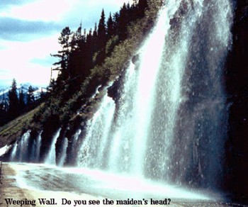 From Kiowa to the next town of East Glacier Park, is about 7 miles and connects you to U.S. Highway # 2. We found the traffic to be very reasonable. The highway was smooth and good to ride. # 2. from East Glacier Park goes South West and then loops back North West to West Glacier. You pass through a couple of small towns, but we noticed they all had gas stations. From East Glacier Park around the bend to West Glacier is 55 miles.
 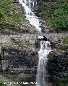 We continued on highway #2, back to Kalispell and our tent. We were very tired and it was late, so we parked the motorcycle, took a shower and walked down the road to a nearby Western café called Fort Kalispell. I checked with Gwen at the campground recently to make sure I had the café's name correct and she said it has closed for good.